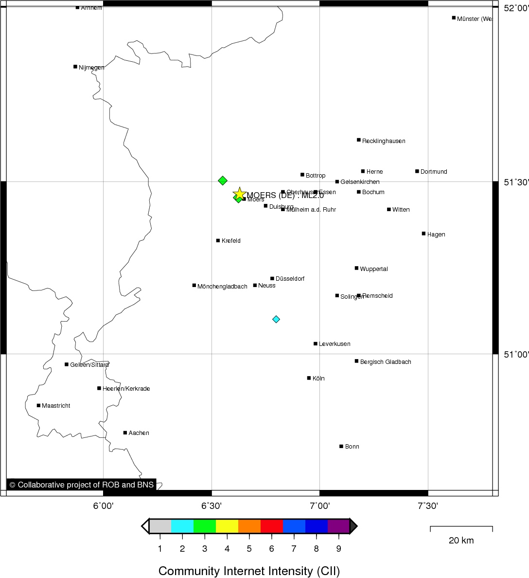
MOERS (DE) - 2011-12-08 04:43:44
- Magnitude 2.0
Last update : 2016-11-24 12:13:30 Belgian time
Main parameters
| Date and time |
2011-12-08 04:43:44 UTC
2011-12-08 05:43:44 Belgian time |
| Type | Known induced event |
| Magnitude | ML 2.0 |
| Maximal intensity | II |
| Region | MOERS (DE) |
| Epicentral coordinates | 51.464° N, 6.630° E Uncertainty ± 9.7 km |
| Depth of hypocenter | 1.0 km |
Data source : ROB (Royal Observatory of Belgium)
Location map
Quake measurements
Measurements by the Belgian seismic network
| Station | Epicentral distance (km) |
P-Wave arrival (hh:mm:ss.ss) | S-Wave arrival (hh:mm:ss.ss) | Maximal ground displacement (nm) |
|
|---|---|---|---|---|---|
| Code | Place | ||||
| MEMH | MEMBACH | 105 | 04:44:00.31 | - | - |
| STI | SART TILMAN | 123 | 04:44:03.85 | - | - |
| CLA | CLAVIER | 149 | 04:44:07.49 | - | - |
| MRD | MAREDSOUS | 184 | 04:44:13.88 | - | - |
| WLF | WALFERDANGE | 203 | 04:44:17.38 | - | - |
| RCH | ROCHEFORT | 176 | 04:44:31.94 | - | - |
| RQR | RONQUIÈRES | 194 | 04:44:38.05 | - | - |
| SKQ | STEENKERQUE | 200 | 04:44:38.90 | - | - |
| DOU | DOURBES | 209 | 04:44:39.13 | - | - |
Measurements by the Dutch seismic network of KNMI (Royal Netherlands Meteorological Institute)
| Station | Epicentral distance (km) |
P-Wave arrival (hh:mm:ss.ss) | S-Wave arrival (hh:mm:ss.ss) | Maximal ground displacement (nm) |
|
|---|---|---|---|---|---|
| Code | Place | ||||
| WTSB | WINTERSWIJK NEW | 57 | 04:43:52.91 | - | - |
| HGN | HEIMANSGROEVE | 92 | 04:43:58.61 | - | - |
| WIT | WITTEVEEN | 150 | 04:44:10.61 | - | - |
Macroseismic
Data
| Total number of responses | 6 |
|---|---|
| Intensity I | 1 |
| Intensity II | 2 |
| Intensity III | 2 |
| Intensity IV | 1 |
Attention! The intensities derived from the macroseismic enquiry are raw unverified data.
Map
Data policy
Please read on this notice to learn more about our data policy.